State of Hawai'i Constitution
See Public Trust Doctrine page for constitutional basis of Conservation, Rights to a Healthy Environment and Agricultural Lands Protection.
State Land Use Law (HRS 205)
Purpose of the Law
In 1961, the Hawaii State Legislature determined that a lack of adequate controls had caused the development of Hawaii’s limited and valuable land for short-term gain for the few while resulting in long-term loss to the income and growth potential of our State’s economy. Development of scattered subdivisions, creating expensive yet reduced public services, and the conversion of prime agricultural land to residential use, were key reasons for establishing the statewide zoning system.
To administer the law, the Legislature established the Land Use Commission. It is responsible for preserving and protecting Hawaii’s lands and encouraging uses to which lands are best suited.
To administer the law, the Legislature established the Land Use Commission. It is responsible for preserving and protecting Hawaii’s lands and encouraging uses to which lands are best suited.
How it Works
|
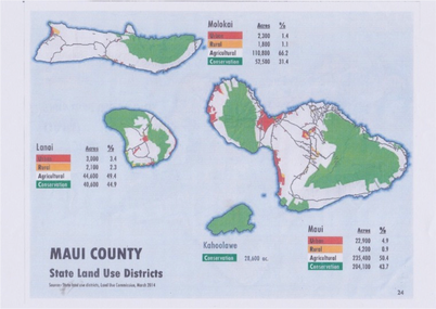
The Law classifies all lands in Hawai`i into four districts:
No amendment to a land use boundary shall be adopted unless it conforms to the State Plan. (§226) |
Maui Land Use Districts
|
Hawai'i State Planning Act
(HRS Chapter 226 1978)
The stated goal was to slow development and shape future growth. It attempted to create a policy framework encompassing the economy, the environment, infrastructure, housing, health systems, social services, individual rights and well-being, public safety, and government.
It aimed to involve broad public support in setting goals and encouraging more conscious, informed and transparent tradeoffs among conflicting goals.
Implementation of the law was assigned to Functional Plans, which were developed by stakeholder groups and approved by the Legislature.
Momentum behind this initiative floundered on a finding that the Functional Plans lacked the force of law. The State Plan was abandoned when George R. Ariyoshi left office in 1986.
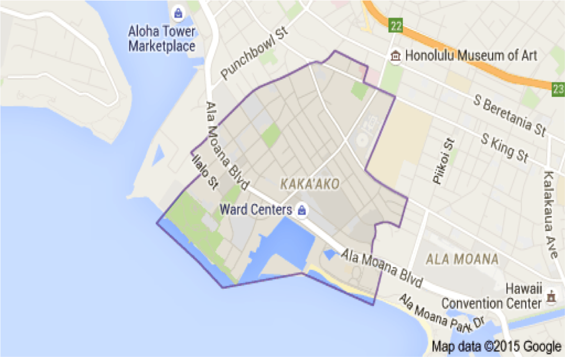
Hawaii Community Development Authority (HCDA)
Passed in 1976 when the legislature determined that many areas of the State are substantially undeveloped, blighted, or economically depressed, and in need of renewal, renovation, or improvement.
Overseen by a Governor-appointed board (HCDA).
Currently, there are only three community development districts on O'ahu (Kaka'ako, Kalaeloa and He'eia) . However, the law applies statewide and the legislature has the power to create a Hawaii Community Development District on any island.
Overseen by a Governor-appointed board (HCDA).
Currently, there are only three community development districts on O'ahu (Kaka'ako, Kalaeloa and He'eia) . However, the law applies statewide and the legislature has the power to create a Hawaii Community Development District on any island.
Land Use Commission (LUC)
Composition
Commissioners are unpaid volunteers and are supposed to represent a cross-section of the community.
- Nine members appointed by Governor and confirmed by Senate
- One member appointed from each of four counties
- Five at-large members
Role
- Ensure State concerns are addressed in land use decisions
- Set boundaries in response to petitions from private landowners, developers, State and County agencies
- Act on requests for special use permits in the Agricultural and Rural Districts
District Boundary Amendment Procedures
- State, County or private owner may petition for a boundary review
- Commission holds hearing in 60-180 day window
- Commission approves, approves conditionally, or denies
- Conditions “run with the land,” binding the present and future until changed
- Decisions on Conservation land require an EIS
- Decisions require six of nine commissioners
A Quasi-Judicial Process
- Gives “due process” to those most directly affected.
- “Parties” may represent themselves or be represented by attorneys or other
- An “intervener” may present witnesses, cross-examine opposing witnesses, and appeal decisions. An intervener may appeal commission decisions to the Hawai`i Supreme Court.
Decision-Making Criteria
Must conform to Hawaii State Plan (HRS Chapter 226)
Must weigh County General Plans and, if applicable, the State Coastal Zone Management Law (HRS Chapter 205A)
Must be cognizant of impacts on:
Must weigh County General Plans and, if applicable, the State Coastal Zone Management Law (HRS Chapter 205A)
Must be cognizant of impacts on:
- natural systems or habitats;
- cultural, historical or natural resources;
- other natural resources relevant to Hawaii’s economy and resources particularly agricultural;
- commitment of state funds and resources;
- economic development; and
- provision for housing opportunities for all income groups, particularly the low, low-moderate, and gap groups.
Exceptions from the Law
- FIFTEEN ACRE RULE: Petitioner may apply directly to County unless land is in Conservation District (1985 amendment)
- AFFORDABLE HOUSING FAST-TRACK are decided in 45 days
- SPECIAL USE PERMITS: “unusual and reasonable” uses of more than 15 acres can be heard by counties, forcing an LUC decision in 45 days after County proceeding
Enforcement of Designations
The lead planning officer or agency of each county is charged with enforcing the land use classification of districts and the condition of agricultural lands (205-4.5), and is also charged with reporting all violations of boundary designations to the LUC.
Five-year Boundary Review
By law, the LUC is supposed to review the classification of all lands every five years.
However, the last five-year review was in 1992
However, the last five-year review was in 1992
“Important Agricultural Lands”
The so-called Important Agricultural Lands act of 2005 (Act 183) is probably the single largest loophole in the protection of agricultural land, contrary to its statement of purpose.
Under HRS 205-45 a landowner may petition the LUC for a declaratory order to re-designate land as Important Agricultural Land in return for re-designating 15% of that land as Urban.
The issue never addressed in court is whether the IAL violates the constitutional protection of AGRICULTURAL LAND.
Under HRS 205-45 a landowner may petition the LUC for a declaratory order to re-designate land as Important Agricultural Land in return for re-designating 15% of that land as Urban.
The issue never addressed in court is whether the IAL violates the constitutional protection of AGRICULTURAL LAND.
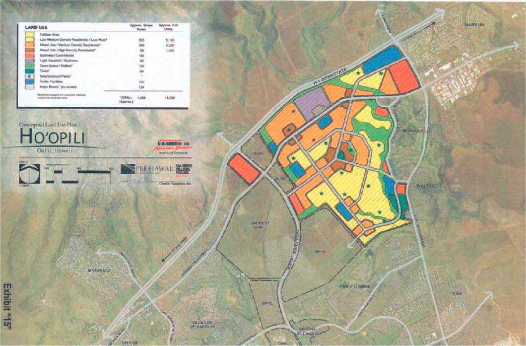
Today’s LUC in Action – A Worst Case Example
LUC Links
Coastal Zone Management Law (HRS Chapter 205A)
|
Pursuant to the Federal CZM Act of 1972, the State CZM was enacted in 1977 to treat the shore-line area as a unique ecosystem.
CZM is a complex act with potentially far-reaching mauka-makai possibilities. Current projects include:
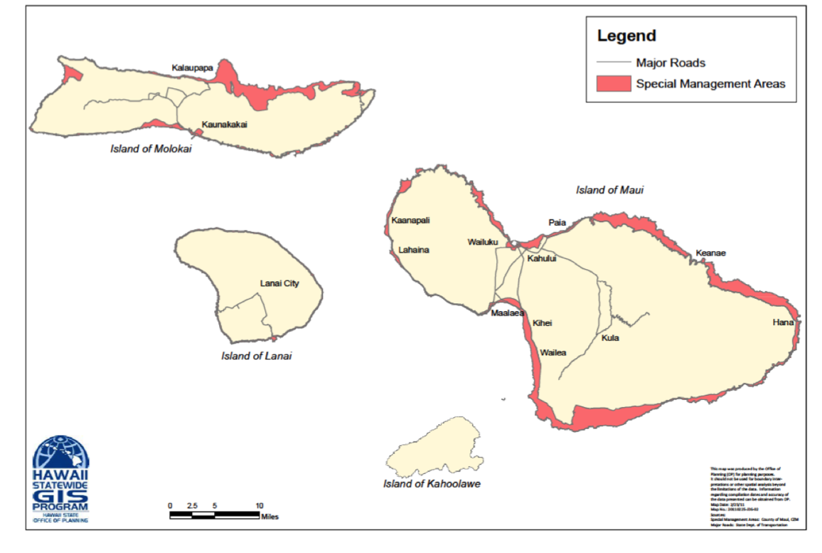
CZM theoretically includes all islands and waters seaward 3 miles. It creates a State shoreline setback zone of a minimum of 20 feet from the high water mark, and a county zone, typically to the nearest major roadway. The Office of State Planning is responsible for CZM. Counties can receive administrative funds from the Federal government but the City and County of Honolulu has opted out. |
CZM - Special Management Areas, Maui County
CZM Links |
Historic Preservation Law
|
Additional Land Use
|
